On Saturday, October 11, Pat Wellner and I took a trip down the Missouri River starting just below the Gavin's Point Dam north of Yankton. We both arrived the night before and stayed at the Chief White Crane Recreation Area. Me in my motor home and Pat in his tent. OK - I didn't exactly rough it. We launched at about 10:00 am from an area near Bubble Beach, next to the Chief White Crane Recreation Area. A good current pushed us downstream at a good rate. As we got close to Yankton the new bridge was about ready to be dedicated and was open to pedestrians. This new bridge is a replacement for the Meridian Bridge, built back in 1924. After passing Yankton we took a short side trip to check out a boat that appeared to abandoned. Shortly after that we made a quick stop to stretch and then headed back downstream. At around 1:00 we stopped at the ramp at St. Helena for lunch and to take a few pictures. After a little over an hour we were back on our way. The day was cloudy and cool all day and we got rained on for a while. When the rain came up we decided to continue paddling. Whether we went to shore or continued to paddle we would have gotten wet. After 10 or 15 minutes of hard rain it quit and we continued along. We considered finding a place to spend the night somewhere in the Bow Creek area, but never found a good place to stop.
Throughout the day we had been monitoring our weather radios and learned that the forecast for Sunday was not promising. With that in mind, we decided to push on and get closer to our ending point, the Clay County boat ramp. At a little after 5:00 we reached a spot near the upstream end of Goat Island and got out to look around. Not finding any good spots to camp we got back in our boats and continued downstream along the island. At a little after 6:00 we found a good place to launch and a suitable camp site a few hundred feet from the shore. Since it gets dark early we hustled to set up camp and have some supper before it got too late on us. With a few stops, about 8 hours after we started we had traveled about 24.8 miles and were only 4 miles away from the Clay County ramp. The night went well, with a little rain around 5:00 am. We got up early, broke camp and were back on the water shortly after sunrise. Well, at least it was getting light. With the heavy cloud cover, the sunrise was not visible. Just after leaving, we rounded a corner of the island and ran into a pretty healthy headwind and some waves up to 2 feet high. With the current and strong paddling, we still maintained a 6 mile per hour pace. The final 4 miles took only 49 minutes and we were at the Clay County ramp and had to unload the boats and head back to Chief White Crane.
A lot of lessons were learned on this trip. We found that a 20 mile trip with a current is not at all difficult. In fact, with a little push, an earlier start, or a little longer day we could have covered the entire 29 mile trip in less than a day. We both had more water and food than we needed, but it is nice to not run short of either important item. We were able to easily carry all of the necessary items in our boats. Both boats run somewhat lower in the water with the loads, but handled well. In fact,I think my Tempest rode better with the longer waterline.
Can't wait to do another trip like this.
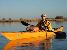
 Pat getting ready to take off

Pat approaching the bridges at Yankton

A bald eagle resting in a tree along the river
 Abandoned boat downstream from Yankton
 Near the St. Helena ramp
 Our boats on the St. Helena ramp

Looking towards James River Island
 Between St. Helena and Bow Creek
 Between St. Helena and Bow Creek
 Near Bow Creek
 Near Bow Creek
 Near Bow Creek
 Near Bow Creek
 Camp site on Goat Island
 Ready to head out Sunday morning

Approaching Clay County
 Boats at Clay County

Looking upstream fom Clay County